Drought, flooding, extreme weather events, invasive species, sea-level-rise (SLR), increasing temperatures of the seas and air, run-off from pesticides and fertilizers, conversion of lands for agriculture and construction, eroding coastal regions due to habitat alteration….All of this is is the focus of the West Indian islands since the affects are much more pronounced in land areas of finite space and resources.
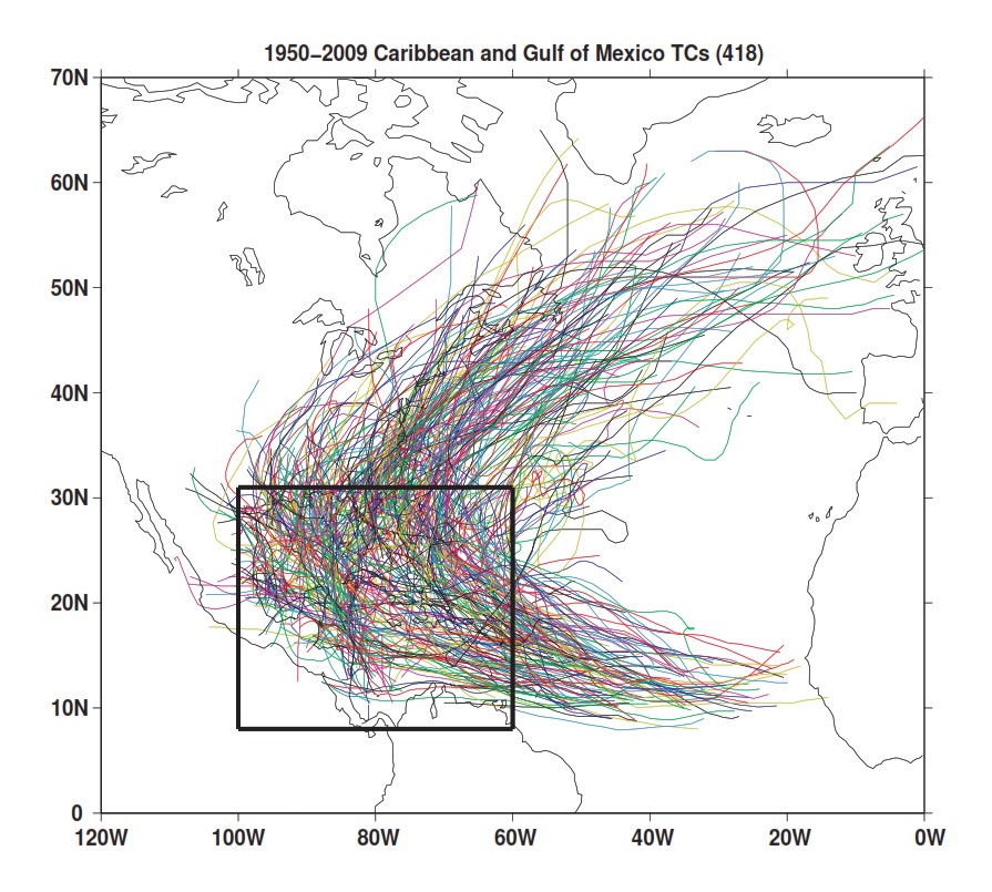
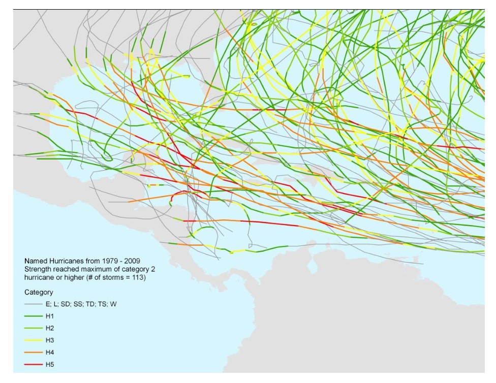
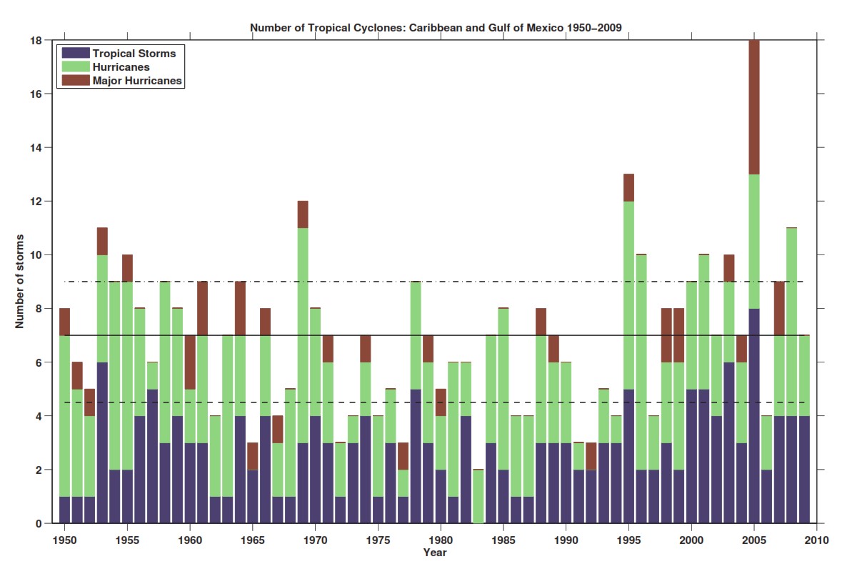
Tracks of 418 Tropical Cyclones reaching tropical storm strength or greater. Most activity occurred between August and October peaking in September. (Sobel, Biasutti, Camargo & Creyts, 2010)Hurricane levels 1-5 for the years 1979-2009. (Levy et al, 2010)Total # of tropical storms, hurricanes and major hurricanes of categories 3-5 by year. Black line=mean # of Tropical Cyclones. The broken lines=75th & 25th % of distribution over the entire record. (Sobel, Biasutti, Camargo & Creyts, 2010)
One of the most effective programs to counter climate change in the last 30 years is a program called Participatory Mapping. Participatory mapping is an attempt to strengthen community-driven public participation in governance and social change through the collaborative collection, validation and display of geospatial data (Degraf, 2015). It is being used on a global scale targeting the Small Island Developing States and low-lying coastal countries (SIDS). It involves the feedback provided from local communities as it affects their lands, cultures and livelihoods.
SIDS have a finite amount of land and resources to begin with; this results in the SIDS undergoing a much more pronounced and retracted recovery period from negative anthropologic and weather affects such as coastal development and natural disasters. The coastal regions are a great source of revenue for the state and livelihood for the local communities. Any loss of the costal zone through extreme weather, erosion, and reef damage adversely affects tourism as well .
Using a data driven approach that includes local and traditional knowledge, models can be developed that address the causes and mitigations necessary to implement solutions as they are needed. This data is available to everyone in the process and is updated on a regular basis. Many SIDS, some with assistance from regional/international NGOs, have plans and implementations of one model or another. The key is including all the stakeholders that have a vested interest in the outcome.
Unfortunately, global warming is here to stay. Finding a balance between a SIDS’s economic growth, conservation of its fauna and the independence necessary to become a self sufficient entity is a difficult path to chart. We wish success to the SIDS in their pursuit of these goals.
Hurricane Dorian, one of the most intense storms recorded in the Bahamas, has hit Abaco Island and turned the island into a disaster zone. The results for the human inhabitants are obvious and somehow measurable. The results on ecosystems or endemic species are much more difficult to measure. See the video below to get an idea how man made climate change can lead to extreme weather events that result in total destruction. We are unaware how the population of the Abaco Island Boa, Chilabothrus exsul has suffered from this event.
Parry, M. L., and Intergovernmental Panel on Climate Change, eds. 2007. Climate Change 2007: Impacts, Adaptation and Vulnerability: Contribution of Working Group II to the Fourth Assessment Report of the Intergovernmental Panel on Climate Change. Cambridge, U.K. ; New York: Cambridge University Press.
Leotaud, Nicole, and Neila Bobb-Prescott. 2013. “The Impacts of Climate Change on Biodiversity and Biodiversity-Dependent Livelihoods in the Caribbean Islands.” In , 55–61. Schoelcher.